|
Delta Soils Of Southeast Missouri
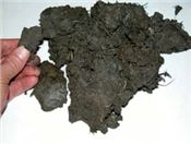
Figure 11. Soil from the surface A horizon in a Sharkey clay soil. Sharkey clay soils are high
in shrink-swell clay which cracks in dry weather.
DR. GENE STEVENS
PORTAGEVILLE, MO.
Part Two Of A Multiple Part Series
Kennett and Sikeston Ridges are level, sandy terraces. They are similar in origin, and are remnants of the Ohio alluvial plain, formed when the Ohio River occupied the lowland east of Crowley’s Ridge. The plain was degraded and destroyed by the Mississippi River when it shifted to occupy this section of the Delta. The ridges were formerly connected, and their edges are marked by slopes, indicating they were formed by stream erosion.
Sikeston Ridge is higher than Kennett Ridge. The elevation of Sikeston is approximately 328 feet, and New Madrid 295 feet above sea level. The elevation of Kennett is 269 feet and Malden is about 292 feet. Both ridges have scars, swales and shallow sloughs, marks of the former Ohio River channels. These are most apparent north and west of Kennett. The area formerly known as Varney River Swamp west of Kennett is a former Ohio River channel. The St. Francis River now occupies an abandoned main channel of the braided Ohio system. Before canalization, the St. Francis River had a poorly defined channel and the exact location of the state boundary was difficult to identify.
Morehouse Lowland
The Morehouse Lowland is the largest subarea of the Delta and includes the area extending from Advance Lowland on the north to the Missouri-Arkansas state line on the south. It is bordered on the west by Crowley’s Ridge and Kennett Ridge, and on the east by Sikeston Ridge and the Mississippi River, south of New Madrid. It has an elevation of about 328 feet near Bell City, and about 256 feet at the state line, or a slope of about 1 foot per mile. That portion of the Lowland south of Morehouse was formerly known as Little River Overflow, because of frequent inundation by water from Castor and Whitewater Rivers.
A subarea of the Morehouse Lowland is a low sandy terrace east of Dexter, and extending from Essex in the north to near Gideon in the south. The surface is marked by numerous marshy depressions from former channels of the braided Mississippi River. The broad, shallow swale in the eastern part of the Morehouse Lowland, and the bordering Sikeston Ridge, was probably the channel before it was abandoned by the Mississippi River. It was a swamp until drained. Except for the Essex terrace, most of the Morehouse Lowland is characterized by a level surface and clay soils.
The New Madrid Earthquakes occurred in the winter of 1811 and spring of 1812. Reelfoot Lake in West Tennessee was created by the earthquakes. In Missouri, soils near New Madrid, Marston, and Portageville were the most affected. The earthquakes caused landslides, uplifts, sunk lands, sand blows, and fissures. Energy from the shaking caused pressure in subsoil sand saturated with water.
The sand was liquefied and forced upward to the surface in cracks and fissures (Figure 8). Smaller earthquakes are common along the New Madrid seismic zone running from Southern Illinois and Northwest Tennessee crossing the Mississippi River into Southeast Missouri down to Jonesboro, Arkansas. Earthquake sand boils are common in crop fields. Sand has a low water holding capacity compared to surrounding silt loam or clay soils in the field, so crops grown without irrigation in sand boils become water stressed quickly during periods of low rainfall (Figure 9).
Eastern Lowland
The Eastern Lowland lies south of Scott County Hills, east of Sikeston Ridge, and is bordered on the east by the Mississippi River. It is a lowland formed by the combined action of the Mississippi and Ohio Rivers. It consists of two subareas called the Charleston terrace and the Mississippi meander belt. The Charleston terrace extends from Morley on the north to East Prairie on the south. The meander belt is the broad lowland bordering the Mississippi River and extending from the Scott County Hills to New Madrid.
The boundary between these subareas is an irregular escarpment, about 10 feet high that extends from about three miles west of Commerce to about six miles south of East Prairie. The elevation at Charleston is 322 feet which is about the same as Sikeston Ridge. The surface of the terrace is bisected by broad swales that mark the former channels of the braided Mississippi River. The surface of the meander belt is uneven because of natural levees and swales of former river meanders. It has the most recent alluvial deposits, and was aggrading until protected by levees.
Soil Genesis
The varied character of the soils of the Delta is due primarily to the soil-forming material, and the drainage condition under which the soils developed. Alluvial sediments from the Mississippi and Ohio Rivers are the parent material of the soils east of Crowley’s Ridge. The loess covered hills of the Ozark Highlands and Crowley’s Ridge have eroded and deposited silt on the surface horizons of soils north and west of Crowley’s Ridge.
The soils of the Delta are geologically young and formed since the Wisconsin glacial age. The thickness of the alluvial material averages over 125 feet but is shallower in some areas. The alluvial soils were formed after the deposition of the loess which covers the ridges. Loess is silt-sized sediment accumulated from wind-blown dust. The more recent deposits are in the flood plain of the Mississippi River and on the alluvial fans of the smaller streams.
The texture of alluvium parent material from different areas of the Delta varied. On the natural levees and low ridges, it was predominantly sandy. Clay was deposited in the wide slack water areas farthest away from the channels. Texture variations are more numerous and contrasting in the meander belt of the Mississippi River. The remnants of the Ohio alluvium of Kennett and Sikeston Ridges is sandy. The Mississippi alluvium is predominantly clay or very fine sand. On the sandy ridges there is a gradation in texture from coarse to fine from north to south. This is most apparent on Kennett Ridge and on the Morley-Charleston sand area. The velocity of the rivers flowing south was decreased when they entered the Delta, and the coarse material was dropped first.
Differences in texture are associated with chemical and mineral differences. Coarser sands contain more quartz. Finer sands generally have a more complex mineralogical composition. The minerals in the recent Mississippi River deposits are fresh and slightly weathered. These are significant factors which help explain the differences in productivity of the sandy soils.
The predominantly silt texture of the soils in the Western and Advance Lowlands indicates the close relationship of the alluvium to the loess mantled upland. This is the oldest alluvium in the Delta, except for Kennett and Sikeston Ridges. The soils developed under poor drainage and have become thoroughly leached and weathered. Variations in the soils are due mainly to recent alluvial deposits by the Black River, St. Francis River, and other streams.
Morphology of the Soil
Soil morphology relates to the profile structure. Soil morphology lowlands in the Delta is expressed in faint horizons for the younger soils and moderate horizons for the older soils on the ridges and terraces. Highly developed profiles do not occur because all the soils are relatively young. Horizons are least distinct on the very sandy soils because of the low clay content. On the other extreme, horizons are also not distinct in heavy clay soils because of slow percolation. Horizons generally are most distinct in soils of intermediate texture as is evidenced by the
Overcup, Dundee, and Dubbs soils (Figure 10). Marked differences in texture within the profile, sand over clay, or clay over sand, are depositional layers, and not genetic horizons. Such stratified horizons are most frequent in the recent deposits near the Mississippi River. Regardless of the number of years since their deposition, the soils are in various stages of weathering and in range of development from slight to moderate. Differences in rate of weathering were governed by differences in the permeability of the soil forming material.
The accumulation of organic matter applies to all soils. It varies in depth and amount of accumulation, but usually is greatest in the clay soils. Organic matter in sandy soils is usually low. The content of organic matter decreases with depth, but its distribution throughout the profile indicates that it was deposited with the sand and clay and not distributed by translocation. This is especially evident in the deep black clay and muck areas.
Because of the high rainfall, all of the soils are leached of carbonates. The most recent deposits near the Mississippi River have been leached the least. Leaching has been most severe on the well-drained sandy soils, as indicated by the generally lower pH. The translocation of silicate clays generally does not occur until the carbonates have been removed.
Reduction and transfer of iron has occurred in the very poorly drained soils. This process known as gleying is the reason for the gray color and color horizons. In Sharkey clay (Figure 11) the gleyed zone may be 6 to 10 inches below the surface in one area, while at other places it may be at a depth of 2 or more feet. In general, the gleyed zone is higher in the profile in the southern part of the clay area than in the northern part, because of the slower drainage. The reduced iron may be removed completely from the soil, or segregate in certain horizons to form concretions and mottles. The loss of iron is indicated by the high mineralization of the ground water. Concretions and mottles are common in soils. They are generally most abundant in depressions or places of standing water. Soils containing many concretions have a harsh brittle structure and are characterized by low fertility. ∆
DR. GENE STEVENS: Professor of Plant Science, University of Missouri
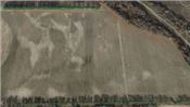
Figure 9. Light colored areas are sand boils caused by the New Madrid Earthquake. During periods of low rainfall crops are often water stressed in these locations.
Photos from Google Earth south of Portageville, Missouri
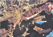
Figure 8. This profile of Crevasse loamy sand soil has sand filled fissures caused by the New Madrid Earthquake. The
soil pit was located near Hayward, Missouri, in Pemiscot County.
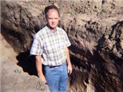
Figure 10. Soil horizons (A, B, and C) in Dubbs silt loam soils at Hayward, Missouri.
|
|