|
Summer 2016 Could Be Similar To Last Summer, MU Researcher Says
COLUMBIA, MO.
Recent winter weather news was dominated by El Niño and its unpredictability. Weather reports late last year and in early 2016 highlighted flooding rains and record snowfalls on the West Coast, severe storms in the South and record-breaking warmth in the Northeast. The Midwest experienced a relatively mild winter and, according to Tony Lupo, a professor of atmospheric science, a fading El Niño could help predict a hot, dry summer.
“El Niño seems to be decaying and that has certain repercussions,” said Lupo, a professor in the Department of Soil, Environmental and Atmospheric Sciences in the MU College of Agriculture, Food and Natural Resources. “The weather pattern helps steer the jet stream toward the Midwest, bringing cooler temperatures from the Pacific Ocean; it usually peaks around November and December and starts to decay in March and April. This year, it is decaying into a La Niña pattern.”
La Niña is a weather pattern that directs the jet stream from the Pacific on a northeastern path over Canada. Rain-producing storms follow the jet stream, leaving states in the central and south-central U.S. dry. When the patterns appear in rapid succession, it can predict more severe weather, Lupo says.
“Summer is when we get into the bad news,” Lupo said. “When El Niño transitions into La Niña as it is expected to do this year, it is usually a predictor of a hot, dry summer. I don’t expect for it to be anything like the terribly hot summer we experienced in 2012, but it could still be bad news for agriculture. A piece of good news for farmers is that we had plenty of rain this winter which should give crops a reservoir.”
Lupo also cautions that severe weather still can occur in the Midwest from March through May. The primary time for severe weather is in the late afternoon and could peak between the hours of 10 p.m. to 1 a.m.
“In our part of the state, severe weather peaks during the hours when most of us are asleep; therefore, it is a good idea to have a severe weather radio with an alarm on hand to warn of approaching storms,” Lupo said.
La Niña and El Niño are regularly occurring climatic features, often alternating every few years. The weather patterns and how they transition were featured in Lupo’s recently accepted study, “2016: An Analysis of the Spring-to-Summer Transition in the West Central Plains for Application to Long Range Forecasting,” in the journal Atmospheric and Climate Science. Rosie Newberry, a former graduate student in the Department of Soil, Environmental and Atmospheric Sciences, co-authored the study. ∆

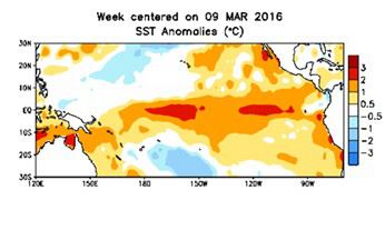
This graphic shows the current state of El Nino as it transitions into La Nina. Tony Lupo predicts that this could indicate this summer could be similar to last summer.
|
|