Using Wireless Sensors To Schedule Irrigation
PORTAGEVILLE, MO.
Missouri has become a leader in wireless soil moisture sensors use by farmers. The benefit of wireless soil moisture monitoring is that a farmer can readily “see” the amount of moisture in his field to determine if irrigation is needed or not. He can view soil moisture graphs on his computer, or even see it on his iPhone.
Cotton, a crop that suffers if either too little or too much water is applied, is a prime candidate for wireless monitoring in Missouri. Data from the annual Bootheel Irrigation Survey since 1997 shows that nearly 10 percent of the time irrigators’ dryland cotton make as much or more than comparable irrigated fields!
Engineers at Cotton Incorporated (CI) have felt that wireless soil moisture data may be the key to assist cotton irrigators throughout the mid- South in fine tuning their irrigation management skills. To this end, CI has provided grant funds to researchers in states in the mid-South to install wireless systems in individual cotton growers’ fields. The Delta Center has been involved with this program for two seasons.
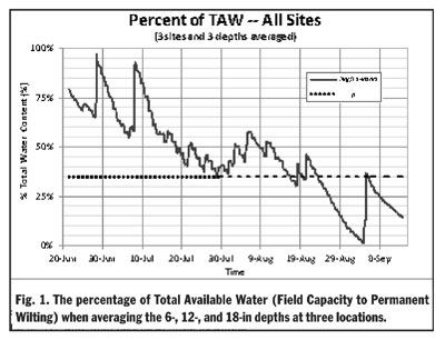
Two pivot-irrigated cotton fields near Hornersville, MO were equipped with Decagon soil moisture sensors provided by CI. In the first year, the 6-, 12-, and 18-inch depths were monitored at three locations placed laterally in the field (so they would all be watered at the same time) in the 3rd, 5th, and 7th span of the pivot. Results from the first year resulted in an additional sensor being installed at the 24-inch depth. Inexpensive rain gauges were also installed.
Data were sent by cell phone modem to a WWW site and the farmers and MU personnel could observe the conditions which were updated about every four hours. For the first year total cost was $3,943 and the annual cost was $7.40/ac/yr. One of the goals of the test was to see if, instead of the three locations under the pivot, two or even one location would suffice. Results from Year 1 showed that irrigation would have been called for at about the same time whether three, two, or just one site was present. This being the case, then the investment cost would have $1,769, or $3.77/ac/yr. To be careful a farmer might want to use less expensive handread sensors in two other satellite locations. This would then bring the cost to $4.83/ac/yr.
In the second year, one notable change was that the equipment was purchased from a local farmer/dealer instead of from the manufacturer in Washington state. The local, farm- savvy dealer was able to address cooperators’ questions and concerns more realistically then university experts. The cooperators, local dealer (Below Ag Services, LCC [Parma, MO]), and Dr. Henggeler could individually observe the plotted data from the sensors and text one another on observations.
In Year 1 the various strategies of using data to trigger irrigation were evaluated; these included:
1) Changes in the extraction curve.
2) Not allowing the 18-inch depth to start to dry down.
3) Irrigating when 65 percent of total available water (TAW) was gone.
Deficit irrigation was practiced in Year 1, making options 1 & 2 difficult to use. Thus, the best strategy was the last one, which was irrigating when the percentage moisture remaining, p, of TAW was only 35 percent (Fig. 1). Note that the field was not allowed to go beyond the 35 percent level until the last week of August when few blooms after that would become harvestable bolls.
First year cooperators reported that this field was the second highest yielding one among all their 17 pivots. One of the changes the sensors caused was having them apply more water than they would have normally done. Δ
DR. JOE HENGGELER: Irrigation Specialist, University of Missouri